
Where to Stay on Koh Chang? Koh Chang isn’t a small island and all the beaches have a different vibe. So deciding which beach to stay on is the most important choice once you have desired to visit the island. So before you...read more...


A ceasefire between Thailand and Cambodia has been in place since 27 December.
Prior to this there was some isolated fighting on the border in Trat province.
So I can understand why many people decided to cancel their holidays.
But, Koh Chang is safe and is very busy. There weren't any direct effects of the fighting on the islands. It is life as normal here.
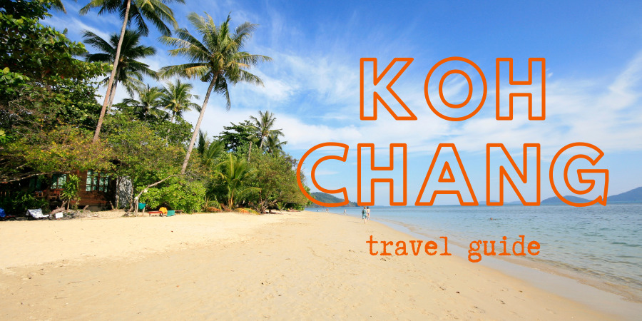
Koh Chang, ('Elephant Island' in Thai) is the third largest island in Thailand and part of the Mu Ko Chang National Park.
Compared to over developed islands such as Phuket and Samui, Koh Chang offers a more peaceful and laid-back atmosphere, making it an ideal destination for travelers seeking to avoid the crowds. With a good range of accommodations, excellent restaurants, and numerous bars, Koh Chang provides a perfect balance of relaxation and adventure.
The 2024-25 high season was the busiest ever and the island, along with nearby Koh Mak and Koh Kood has seen a noticeable rise in the number of visitors. Change is coming, but at a relatively slow, manageable pace.
The 2025-26 high season has been a little quieter due to the border dispute.
You're almost certainly coming here for a beach holiday. So, here's a brief run down of the island's main beaches. These are all on the west coast, with White Sand beach in the north and Lonely beach in the south. In between, you have Klong Prao - the longest beach on the island and Kai Bae beach.
Bear in mind that each beach has a different atmosphere. So there isn't necessarily a 'best beach on Koh Chang'. Everyone will have their own opinions about that. :-)
There are other, quieter, beach areas on the island and you'll learn more about them in the Island Guide below which covers all corners of the island, not just the main beaches.
Where to Stay on Koh Chang? Koh Chang isn’t a small island and all the beaches have a different vibe. So deciding which beach to stay on is the most important choice once you have desired to visit the island. So before you...read more...
I've mentioned a few places to stay above. But I've also written some handy guides on accommodation on Koh Chang which cover different types of places.
If you want to avoid reading through the hundreds of reviews on this site then just go to this extensive rundown of the best accommodation on Koh Chang. This covers everything from 5 star resorts and pool villas to guesthouses and simple beach huts.
You'll find all types of accommodation on the island. For visitors on a tight budget there are some great hostels.
Or for those of you who want to avoid the larger resorts but enjoy some home comforts, Koh Chang has a growing number of boutique resorts. Take a look at some of the best boutique stays.
Airbnb rentals were taking off on Koh Chang before coronavirus and they are sure to be even more popular now. Expect more space than a hotel room and better value for money. Plus privacy and all the comforts of home. So, I've also got some picks of the best Airbnbs on the island.

My Picks for the Best Hotels, Resorts, Pool Villas and Bungalows There are reviews of around 100 places to stay on Koh Chang in the Accommodation section. This page is about helping to narrow the choice. Just a selected...read more...
Having decided on a holiday on the island and checked out a few hotels, all that remains is to figure out how to get to Koh Chang from Bangkok or elsewhere. Whether you plan on travelling by bus, plane or private car or minibus, you'll find all the information you need in the Transport section.
In brief, if you are on a budget then there are regular bus services from Ekamai Bus Station, Bangkok to the mainland ferry piers. Or you can book tickets for a shared minibus that would pick you up from your hotel in Bangkok or Pattaya and drop you off at your hotel on Koh Chang.
Private transfers by car or van are also easy to arrange for couples, groups or families who want to get here with the minimum of hassle.
If you plan on flying, Bangkok Airways has 3 or 4 flights a day to Trat Airport, from where Koh Chang is a short minibus and ferry ride away. As you'll see from the guide, passengers can easily take a minibus direct from Trat Airport to their hotel on Koh Chang.
There's also a useful page on getting around Suvarnabhumi Airport in Bangkok, which is the entry point to Thailand for most western tourists. Learn the layout of the airport and the best place to exchange money, how to get into the city centre or direct to Koh Chang etc.
As Koh Chang is an island, with no bridge or airport, you'll have to take a boat to get here. The boats to Koh Chang are all large car ferries. These run from 06:00 - 19:30 daily throughout the year and depart from two piers on the mainland.
Detailed timetables and information can be found on this bus and boat timetable page.
An ever increasing number of people are combining Koh Chang with a trip to Cambodia, either to Angkor Wat or the islands in the south. Fortunately, getting to Koh Chang from Siem Reap or Phnom Penh is relatively simple nowadays. You'll find more on this in the transport section.

Bus Timetables and Boat Schedules to Koh Chang Koh Chang Bus Timetables Before you email to ask, there are no trains due to the lack of railway tracks in this part of Thailand. The bus...read more...

Private Transfers by car, SUV or Minibus to Koh Chang As of 1 May 2025 I’m no longer arranging transfers. Many thanks to the thousands of people who have booked over the past 18+ years...read more...
For many people a holiday is just about lazing in the sunshine and enjoying sunset cocktails. But there's plenty to do away from the pool and beach.
There are numerous activities to keep you occupied when you aren't sunning yourself. Including jungle trekking, snorkeling trips, jungle trekking, cooking classes, ATV riding, treetop adventure park, massage, scuba diving courses and elephant trekking.
And if you want to explore the interior of the island, grab a scooter and head off to discover various waterfalls which can easily be reached on foot. Or take a tough trek to the top of one of the mountains.
Afterwards, you may well need and inexpensive Thai massage to soothe your aching limbs.

Jungle Trekking on Koh Chang Surprisingly, few people bother making the effort to head into Koh Chang’s interior on a trek. But if you need some exercise whilst on holiday jungle trekking is...read more...

Koh Chang Snorkelling Guide Snorkelling is one of the most popular activities for visitors to Koh Chang. The best snorkelling sites rival those you’ll find in the south of Thailand...read more...
We've lived on the island since 2003 and in addition to running this site also have a small guesthouse, 'Baan Rim Nam' on Klong Prao beach which we rebuilt during covid.
I also post updates and snippets of info, photos and random ramblings on Facebook,com/iamkohchang
Message me if you need any specific information you can't find on the site.

Introduction Thinking of living or retiring in Thailand? You’ve probably seen plenty of articles claiming to know the “real” cost of living, but the truth is, most of them rely on one person’s...read more...
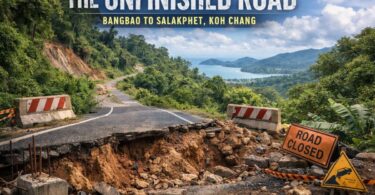
The Bangbao to Salakphet Road One of the questions many visitors to Koh Chang have, after spending five minutes looking at a map, is ‘Why isn’t there a road around the island?‘...read more...